New Canopy Cover Data for Albuquerque

New high-resolution canopy cover data are available for the Albuquerque metro area. Developed from National Agriculture Imagery Program (NAIP) imagery, the 0.6-meter resolution canopy map provides the clearest picture yet of the extent and distribution of Albuquerque’s urban forest resource during the summer of 2020. The data have an overall accuracy of 93%.

Data area downloadable as 0.6-meter and 30-meter grids here: https://tnc.box.com/s/8r4tkrrdi7d9vgwjd6oj3ad88z40iyr3

The code used to produce the new canopy cover data are available here: https://github.com/sbassett/ABQ-Canopy-Cover-2020

A poster-sized map of these new data is also downloadable here: https://tnc.box.com/s/b2hftlgt78wapp91y8a82wfnv2mwuyy0

This analysis was presented at the 2022 Land and Water Summit on March 3rd 2022. The presentation is available here: https://tnc.box.com/s/aq4d1erwxh10ywl90l365xa4sdt4c79p

Creating a Burned Area Learning Network

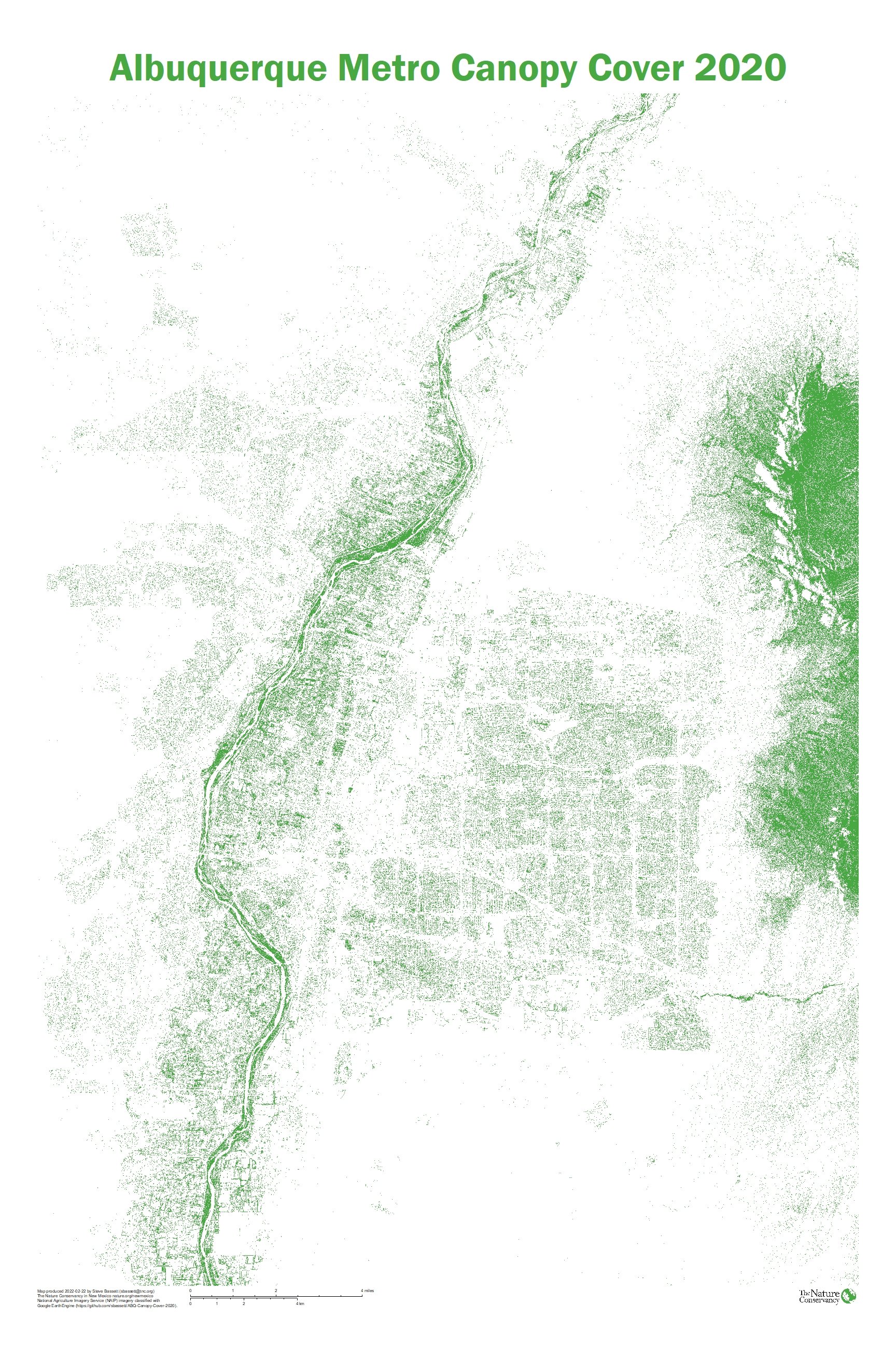
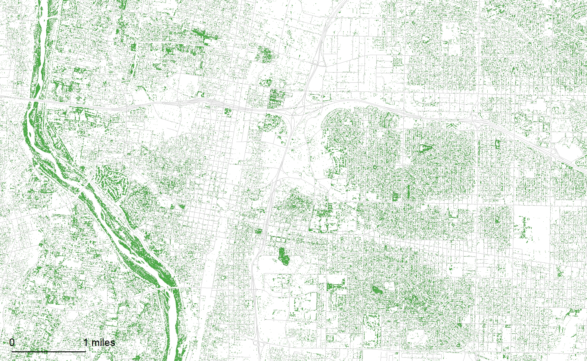
Wildfires in the West are increasing in size and severity, driven by unhealthy fuel conditions, and a warming, drying climate. Impacts to communities and watersheds do not end when burning stops. Post-fire processes—flooding, erosion, invasive exotic species and loss of watershed function—can last for decades and have profound impacts on communities far outside the original fire boundary and to species reliant on intact forests. Climate change is exacerbating fire severity and size, and in some areas it creates uncertainty for post-fire vegetative recovery. In the Southwest, there are concerns that large, severely burned landscapes in pine and mixed conifer forests won’t reestablish in the warmer drier climatic regime. Through our experience with large fires, we have realized that we need to extend our fire management and science work to encompass the full fire cycle — prefire mitigation, good fire practice, and appropriate response after fire.

TNC works with partners to address postfire impacts

Since 2015, TNC has been working with a broad set of collaborators, to address the growing need for a more comprehensive postfire response, through a “Burned Area Learning Network”, an initiative of TNC’s well-established Fire Learning Network. A learning network is an intentional collaborative effort that brings people together on a topic to share ideas and accelerate the transfer of new knowledge. Learning networks provide a way to successfully attack complex problems because they bring together people working on different elements of the post-fire problem, who can then effectively share their solutions with many other people, who in turn offer their own take on the questions and answers important to them.

The goal of the Burned Area Learning Network (BALN) is to accelerate learning by peer-to-peer knowledge sharing to improve social and ecological outcomes following wildfire. Through our collaborative efforts we seek to:

  • improve the accuracy and utility of short- and long-term post-fire risk assessment;

  • increase worker safety during burned area assessment and restoration;

  • improve inter- and intra-agency relationships and policies; and

  • develop new science-based cooperative strategies for post fire response.

The premise of the BALN is that is that we can achieve better outcomes by conducting pre-fire planning that includes post-fire response. We can engage communities and land managers in a non-emergency setting and provide the most efficient way to integrate the existing science, share lessons learned, and develop an adaptive feedback mechanism to incorporate new information

By working collaboratively, the Burned Area Learning Network has been creating opportunities to share lessons learned during postfire recovery, and to create tools to prepare for and mitigate potential impacts.

Recent products of the BALN partners

https://tnc.box.com/s/s3kmbj66ojtju7lm15hsxwd8fq11bakp

Joint learning on the ground

Manzano Moutains Field Tour

Santa Clara Canyon Field Tour including small scale erosion control techniques 

State of the Knowledge: postfire response summary paper

Cross-boundary coordination

3 state postfire field tour storymap  Describes the topics discussed on large burned areas in Colorado, Arizona and New Mexico

Postfire collaborative workshop Wenatchee, Washington 2017

Longer term postfire recovery efforts

The ongoing recovery of Santa Clara Pueblo after the 2011 Las Conchas Fire  A Tribe's Collaborative Journey To Develop Forest Resiliency (arcgis.com)

The Joint Fire Science Program’s Southwest Fire Science Consortium has hosted multiple webinars and working papers on postfire environments.  Their offerings can be found here:

 https://www.swfireconsortium.org/tag/post-fire-environment-management/

Policy considerations

  Federal policies that guide or constrain postfire emergency response

Prefire Planning

The Greater Santa Fe Fireshed is a 107,000 ac. landscape in the southern Sangre de Cristo Mountains in New Mexico.  Collaborators have evaluated by the risk of wildfire and postfire flooding and debris flows. Prefire planning for postfire response in the Greater Santa Fe Fireshed 

Postfire  preparation during Community Wildfire Protection Plan revisions:

Village of Angel Fire, New Mexico

Black Forest, Colorado

Rio Arriba County, New Mexico

Postfire risk assessments links to NMFO- create summary sheets?

Community resources after fire

The After Wildfire website with financial and other resources for community recovery https://afterwildfirenm.org/

TNC Nature Based Hazard Mitigation and use of FEMA grant opportunities Promoting Nature Based Hazard Mitigation

Colorado Postfire Playbook  provides an actionable worksheet that includes specific and critical steps to take and contacts to make before, during, and within the first 30 days of a fire to facilitate community recovery.

Postfire restoration science and  landscape strategies

The East Jemez Landscape Futures Project  https://www.eastjemez.org/ and https://tnc.box.com/s/ig6od45fa8grrhermqzmji2q7lop391y

Postfire Management in Southwestern Conifer Forests ( presentations at the Ecological Society of America meeting August, 2020)  Postfire mgt of SW Conifer Forests

Reforestation

 Climate adapted postfire reforestation  WCS factsheet

 Description of work needed to reforest after fire.   After the Fire: Reseeding New Mexico's Future

Managing NM's Natural and Working Lands for Carbon Benefit

The Nature Conservancy in New Mexico and Colorado are collaborating on a project funded by the bipartisan U.S. Climate Alliance (USCA) that will explore how we can tackle climate change with land-based approaches to sequester and stabilize carbon.

Using the best available data to inform our modeling approach, TNC will estimate the increased carbon sequestration and avoided emissions through conservation and land management practices on forests and agricultural working lands. 

Key to this work is the engagement of technical and policy stakeholders to help prioritize which of these practices are evaluated for their potential carbon benefit. It is our hope that these science-based results and the stakeholder engagement will inform investment in state and local climate action policies.

Ranchlands.jpg

How to contribute your expertise

If you missed the workshop, you can watch the full recording, or if you just need a reminder you can download the presentation slides from our January 12, 2021 workshop.

Resources

Below is table of draft “pathways” that will be considered for modeling. We will not be able to model all the potential pathways and would like to reduce the list based on feasibility of adoption. For example, we do not want to model a pathway that is unlikely to be adopted.

SurveyPathways.jpg

East Jemez Landscape Futures

Edge Effects, a 2018 art installation at Bandelier National Monument with art from Kathleen Breannan and Shawn Skabelund, photo credit: Minesh Bacrania. For more information, video, and images see: https://www.brennanstudio.com/east-jemez-project-20…

Edge Effects, a 2018 art installation at Bandelier National Monument with art from Kathleen Breannan and Shawn Skabelund, photo credit: Minesh Bacrania. For more information, video, and images see: https://www.brennanstudio.com/east-jemez-project-2018.html

The East Jemez Landscape Futures (EJLF) project is a collaborative, landscape-scale approach to help guide future planning and research efforts in the severely altered landscapes of the eastern Jemez Mountains. EJLF seeks to address uncertainty by building a network of land managers, scientists, artists, NGOs and interested community members to inform future management, identify research needs, and capture stories from individuals and communities who were affected by these changes.

Learn more at: www.eastjemez.org

Download the Needs Assessment, (2017) 

Overview

We have divided the EJLF project into three interwoven paths:

Some areas in the eastern Jemez Mountains have started to recover from the fires, others need may need some help. The EJLF project seeks to identify and address the areas that may need a jumpstart. Credit: Megan Heeres

Credit: Collin Haffey

Credit: Collin Haffey

  • Art and story - In order to meet the challenges in front of us in the East Jemez we need to break through the barriers that prevent true interdisciplinary work. We are working with artists, local storytellers, landscape architects, and scientists to develop ideas and experiments for action in the East Jemez. We will use these collaborations to help guide the restoration and management efforts moving forward.

  • Research and science - Collectively, we have been learning from the Jemez Mountains for centuries. The recent changes provide nearly infinite questions. The answers will support land management decisions in the Jemez and throughout the West. As we move forward in the project we'll be setting up experiments and monitoring along the way. The experiments will help us identify patterns and ultimately the processes driving the successional trajectories.

  • Restoration and planning - During the needs assessment phase of this project it became clear that people were eager to get started with work. Groups are beginning to form around specific watersheds in the east Jemez to get down to action. These groups are interdisciplinary and are taking a holistic look at ecological restoration. We will work to make sure that communication channels between groups stay open. We will organize field trips, workshops, and coordinated planning to make sure we are working as a community in the eastern Jemez.

Next Steps & Timeline

In fall of 2018 the EJLF project was awarded a grant from the Bureau of Reclamation (BOR) to establish a watershed restoration plan for the east Jemez. Sasha Stortz and Collin Haffey are coordinating the effort. The BOR funds are scheduled to arrive in spring of 2018 and will support the development of a watershed group and collaborative planning effort. Once completed, the members of the watershed group will be eligible for additional BOR funding for implementation. Ahead of the funding Sasha and Collin are working to develop a “steering committee” to determine how to engage with a broad set of partners in the eastern Jemez and identify potential goals and outcomes of the watershed group. If you are interested in participating in the watershed group or have questions about EJFL please contact Sasha or Collin, Sasha.Stortz@nau.edu or collin.haffey@tnc.org Once the funding becomes available (Spring 2019) we will being the process of developing a restoration plan and watershed group. Likely this will start with a kickoff meeting in early spring and it would be great to get updates from folks who have been working on post-fire restoration. From there we will continue working to meet the requirements of the BOR and gain access to the BOR's Phase 2 funding.

Rio Grande Water Fund

Rio Grande Water Fund Activities in 2018.

New Mexico’s Rio Grande and its tributaries supply water for wildlife and 1 million people. The health of these waterways is key to the health of Albuquerque, Santa Fe, Native American Pueblos and other communities—half of New Mexico's population—and an essential ingredient for our state’s economic growth.

Established in 2014, The Nature Conservancy’s Rio Grande Water Fund is a groundbreaking project that protects and restores vital forests upstream in order to ensure a continuous supply of clean water downstream. 

The Rio Grande Water Fund protects forests and water for 1 million people in northern New Mexico and boosts local economies by creating jobs and wood for products. The project is also generating a sustainable source of funding for a 20-year program to restore 600,000 acres of forest north of Albuquerque.

BENEFITS OF THE RIO GRANDE WATER FUND

  • Clean and secure water

  • Outdoor recreation and tourism

  • Jobs in rural communities

  • New Mexico-grown wood products

  • Healthy fish and wildlife

  • Reduced wildfire risks

Clean Energy Workshop

© Jim Richardson

© Jim Richardson

On November 28, 2018, The Nature Conservancy convened a bipartisan group of New Mexico state legislators, utility industry representatives, local government officials, and others for a half-day clean energy workshop in Albuquerque, NM.  At the workshop, attendees learned from a team of expert policy faculty in a variety of issue areas, they shared stories with one another and had discussion about making New Mexico more competitive in the clean energy marketplace.  Energy storage, grid modernization, renewable energy, and electric transportation were discussed.  Attendees were also provided with resources to assist in developing state clean energy policy, such as the State Policy Opportunity Tracker (SPOT) for Clean Energy, a 50-state clean energy policy gap analysis.  As well, attendees learned about the Advanced Energy Legislative Tracker, a database that tracks all introduced state clean energy legislation and the Clean Energy Policy Guide for State Legislatures, a guide that outline key policy design.

This workshop represented the first step in The Nature Conservancy’s goal to build a long-term coalition of diverse clean energy stakeholders advocating for policies and supporting projects that reduce greenhouse gas emissions in multiple sectors in New Mexico.

Handouts

Presentations

Seeing the City for the Trees: Mapping Albuquerque’s Urban Forest

Albuquerque’s trees were mapped with 1-meter resolution aerial photographs taken in the summer of 2016.

Albuquerque’s trees were mapped with 1-meter resolution aerial photographs taken in the summer of 2016.

Trees produce economic, social, health, and aesthetic benefits (Roy et al. 2012). Efforts are underway to increase the tree canopy in Albuquerque, New Mexico. Mapping the existing extent of tree canopy in the city will enable targeted investment in increasing canopy cover.

In this analysis, tree canopy was mapped from 4-band 1-meter resolution aerial photographs captured in the summer of 2016 by the National Agriculture Imagery Program (NAIP) using a Classification and Regression Trees (CART) classifier and hand digitized training data in Google Earth Engine (GEE). Canopy rasters and a poster featuring this data are publicly available.

Methods

To develop the training data points, NAIP imagery was downloaded for the study area from the USGS Earth Explorer database (earthexplorer.usgs.gov), then training points were manually digitized in ArcMap. The most recent NAIP imagery for the analysis area was captured over five days between 2016-06-14 and 2016-07-05. Image quality is generally high, with a few obvious breaks between image swaths.

Over 10,000 training data points were created. Training points were classified as either canopy (1) or not canopy (0). Training points were distributed across the study area with extra intensity in areas where the model was expected to have a more difficult time distinguishing between canopy and non-canopy, such as irrigated fields and shadows.

To provide more distinct bands for differentiating classes in the classification model, the NAIP imagery was processed in GEE. Besides the four bands collected in the NAIP imagery (infrared, red, green, and blue), normalized difference vegetation index (NDVI) and enhanced vegetation index (EVI) were also generated. Neighborhood entropy for each of the bands was calculated for a 4-pixel radius around each cell. These bands were then combined into a multi-band image to train the CART classifier.

The trained CART classifier was used to classify the multi-band image. The classification layer was then exported for cleanup in ArcMap. Four passes of a majority filter were used to remove artifacts from the classification process. Eight neighbors were evaluated in each pass with a replacement threshold of “half”.

To analyze the accuracy of the classification, a confusion matrix was created. The training data points were used as the ground truth and compared to the raw classification and cleaned classification datasets.

Results

Percent canopy cover for the entire study area is 11.4% for the cleaned classification and 13.2% for the raw classification. For the Albuquerque developed area excluding the Rio Grande Bosque, the canopy cover is 12.9%. The Bosque has a canopy cover of 47.5%. Including the Bosque, the Albuquerque developed area has a canopy cover of 13.7%.

The confusion matrix that compares the classification and ground truth of over 10,000 pixels indicates the original classification is more accurate than the cleaned data with an overall accuracy of 95.78% compared to 93.29% for the cleaned data (Tables 1 & 2). Even with its decreased accuracy, the cleaned classification data may be more useful for some applications, such as block-level maps where pixelated artifacts of the classification process may confuse map readers.

Table 1. Confusion matrix of the raw CART classification. Canopy is classified as 1, non-canopy as 0.

Table 1. Confusion matrix of the raw CART classification. Canopy is classified as 1, non-canopy as 0.

Table 2. Confusion matrix of the cleaned CART classification. Canopy is classified as 1, non-canopy as 0.

Table 2. Confusion matrix of the cleaned CART classification. Canopy is classified as 1, non-canopy as 0.

Discussion

NAIP imagery was selected from the available data sources due to its relative currency, high resolution, and high accessibility. LiDAR data has been collected for the Albuquerque metropolitan area but could not be processed in GEE. Satellite imagery is also available for more recent time periods and with higher spectral resolution but is only available at courser spatial resolutions.

The difference between the original and cleaned canopy models is due to small canopy areas being removed in the majority filter process. Small gaps in the canopy were also removed by the majority filter. The raw and filtered canopy rasters can be downloaded here.

Because the NAIP imagery for the analysis area was captured over five days, there are several regions that appear less saturated than the neighboring swath; in these areas canopy cover is predicted to be slightly lower than in the neighboring high saturation areas. These areas are most obvious northeast of the Sandia Mountains. The imagery covering the developed portion of the study area was collected on one day and doesn’t have apparent differences between image swaths.

About two thirds of errors are commission errors, where canopy is predicted but is not truly present. Commission errors are most prevalent in areas that are green but are not canopy, like edges of irrigated grass and green roofs where entropy is high. The limited spectral bands available from NAIP render these features indistinguishable from tree canopy. Additionally, the wide range of tree species in the study area also increase the range of underlying parameters in the canopy class. Everything from stressed piñon to irrigated orchards are trained as the same class despite significant differences in spectral appearance. Other non-canopy areas fall into these same ranges, especially deep shadows, green roofs, and the edges of fields. To further refine this analysis, LiDAR data could be used to remove areas classified as canopy that have zero relief above the ground surface. Omission errors are due to an under-trained model where the classifier does not recognize the cell as canopy. Additional training data could be added to improve the classifier.

References

Roy, Sudipto, Jason Byrne, and Catherine Pickering. 2012. “A Systematic Quantitative Review of Urban Tree Benefits, Costs, and Assessment Methods across Cities in Different Climatic Zones.” Urban Forestry and Urban Greening 11 (4): 351–63. https://doi.org/10.1016/j.ufug.2012.06.006.

Southwest Climate Change Initiative

NM_logo_CMYK.png

The Earth’s climate is being disrupted irrevocably by the accelerated release of greenhouse gases into the atmosphere. In fact, climate change is already well underway in the southwestern U.S.— more so than anywhere else in North America, outside the northernmost latitudes—and it is already affecting native plants, animals and habitats in ways we can see and measure. The challenge to the conservation community is to manage our forests, grasslands, deserts and rivers to build resilience and to reduce the adverse impacts of climate change on people and nature. Now is the time to prepare for more change. Any action we take now to understand the local effects of climate change and to build ecosystem resilience will help protect our natural areas and the clean water, clean air, and wildlife habitat they provide. The Nature Conservancy has joined with the Climate Assessment for the Southwest (University of Arizona), National Center for Atmospheric Research, Western Water Assessment (University of Colorado) and Wildlife Conservation Society to form the Southwest Climate Change Initiative (SWCCI). Our aim is to provide information and tools to build the resilience of natural areas in Arizona, Colorado, New Mexico and Utah.

Landscape Workshops

The Nature Conservancy initiated the SWCCI in 2008 to provide guidance to conservation practitioners and land managers in climate change adaptation planning and implementation on more local scales. This project specifically aims to: (1) further develop and expand our impacts assessment protocol to adjacent states in the Southwest (AZ, CO, and UT), and (2) apply a vulnerability assessment tool being developed by the U.S. Forest Service and an adaptation planning framework developed by a Wildlife Conservation Society (WCS) and National Center for Ecological Analysis and Synthesis (NCEAS) working group to a series of case-study sites in the four states.

The case studies were conducted as a series of landscape workshops and provided opportunities to further test and refine each component of the overall adaptation framework, by building on new research, strengthening existing partnerships, and laying the foundation for future innovation, including on-the-ground application and testing of adaptation strategies. Together, these field-tested tools will be useful in developing conservation action and monitoring plans (e.g., a climate change module in TNC's CAP process), forest and fire plans, and in building a regional learning network, all crucial to meeting the challenges posed by climate change for conservation.A series of landscape workshops where scientists and managers explored how to use climate change information to adjust their management practices. The documents below illustrate how focusing on climate change in a particular landscape can generate specific and concrete ideas for climate adaptation action.

Downloads

Climate Change Adaptation for People and Nature (March 2012)

  • In the U.S. Southwest, global climate change, acting in concert with extant stressors such as urbanization and over-allocation of water resources, is changing ecosystems in measureable and sometimes dramatic ways. Twentyfirst century projections indicate accelerating climate change and cascading ecological consequences. Our experience suggests that adaptation efforts can be effective if they are focused at the local scale; employ learning networks; and engage in ecosystem-based adaptation: the sustainable management, conservation and restoration of ecosystems so that they continue to provide the services that allow people to thrive in changing environments.

Evidence of Climate Change in NM (April 2008)

  • There is now strong scientific evidence that human-induced climate change is affecting the earth's species and ecological systems. The Nature Conservancy's state-wide assessment of recent climate change enables practitioners and managers to make better informed decisions and to take action in the near-term by identifying the potential vulnerability of habitat types, priority conservation sites and species to climate change.

Evidence of Climate Change in NM (December 2008)

  • The second of three reports assesses the conservation implications of recent climate change on New Mexico’s watersheds and hydrology. Analyzing recent trends (1970-2006) in a water balance variable—climate water deficit—that indicates biological moisture stress or drying, this study identifies watersheds of high conservation importance in New Mexico that are most and least vulnerable to ongoing climate change.

Managing Changing Landscapes in the Southwestern United States (January 2011)

  • This regional assessment examines the impacts of temperature change from 1951-2006 on natural resources in Arizona, New Mexico, Colorado, and Utah. It documents that warming has already affected habitats, watersheds, and species in the Southwest, by influencing the timing of seasonal events or amplifying the impacts of natural disturbances such as wildfire and drought. The report concludes that to begin adapting to climate change, natural resource managers should reevaluate the effectiveness of current restoration tools, modify resource objectives, learn from climate-smart adaptive management and monitoring, and share information across boundaries.

New Mexico Climate Change Ecology and Adaptation Workshop (October 2007)

New Mexico Statewide Natural Resources Assessment, Strategy and Response Plans

Wildfire risk modeled by TNC during the development of the 2010 Statewide Assessment.

Wildfire risk modeled by TNC during the development of the 2010 Statewide Assessment.

The New Mexico Statewide Assessment, Strategy and Response Plans identify natural resource conditions, needs and opportunities across all land ownerships in the state. Based on the currently available statewide geospatial resource data, this set of collaboratively developed resource models and map products helps identify priority landscapes for restoration and resource management.

New Mexico Statewide Natural Resources Assessment

The Assessment was developed through a partnership between ENMRD Forestry Division, the New Mexico chapter of The Nature Conservancy, the Forest Guild, and nearly one hundred stakeholders and partners who provided the resource information, advice and insight that guided the project. The data of the Assessment were organized around eight data themes. Themes were suggested in the 2008 Farm Bill and outlined in guidelines provided by USDA Forest Service (Redesign Components: State Assessments & Resource Strategies). Some of these themes were adapted for New Mexico by the Stakeholders.

These themes are (with Forest Service language in parentheses if adapted):

  • Biodiversity (Fish and Wildlife Habitat)

  • Development Potential (Development Risk)

  • Economic Potential

  • Forest Health (Risk)

  • Fragmentation (Forest Fragmentation)

  • Green Infrastructure

  • Water Quality and Supply

  • Wildfire Risk

Further information on the resource data models developed for the Assessment is available in the Data Atlases: Methods and Descriptions of Core Data Models. Maps are also available.

New Mexico Forestry Division Statewide Strategy and Response Plans

The New Mexico Forestry Division Strategy and Response Plans intend to guide long-term Forestry Division management. In the Strategy Plan, the resource models were combined to represent Four Key Themes to help the Division identify priority landscapes for management.

  • Conserve Working Landscapes

  • Protect Forests and Watersheds from Harm

  • Enhance Public Benefit From Natural Resources

  • Promote Urban and Community Forestry

For each Key Theme, the Forestry Division identified the Issues, Trends, Barriers to Addressing the Issues and the Strategies proposed for implementation and delineated the priority landscapes where the Forestry Division and partners can work to address the issues. In the Response Plan, the Forestry Division identified how they plan to invest programmatic and personnel resources to address the priorities proposed in the Strategy Plan, including how federal and other funding will be invested and how Forestry Division objectives align with national State and Private Forestry objectives. Online copies of the document are available.

Downloads

Wildfire Risk (November 2009)

  • The Wildfire Risk data model identifies areas with a relatively high risk of destructive wildfire. The intent of this layer is to highlight areas where management is most likely to reduce the risk of wildfire damage, which is defined as reducing the impact of wildfire on natural resources, and human infrastructure and development. The model combines three modeled fire behavior parameters (rate of spread, flame length, crown fire potential) and one modeled ecological health measure (fire regime condition class) with wildland urban interface areas and ignition probability.

Water Quality and Supply (November 2009)

  • The intent of the Water Quality and Supply data model is to prioritize watersheds important for supplying sustainable water along with the potential risks to water quality. For the foundation of the model, the technical team identified the following 10 available data layers: public drinking supply, priority watersheds identified by the New Mexico Nonpoint Source Management Program (WQCC 2009), impaired waters (see below for complete description), specific New Mexico Environment Department (NMED) impaired/impacted watersheds, percent irrigated cropland and pasture, NMED water quality risks, aquifer recharge areas, aquifer vulnerability, impervious surface, and erosion risk.

Green Infrastructure (November 2009)

  • Green Infrastructure for the purposes of this model represents an interconnected system of natural areas and other open spaces that are protected and managed for the ecological benefits they provide to people and the environment.The Green Infrastructure data model connected 20 key natural and protected areas using a least cost path analysis. The key areas, or hubs, include the 10 most diverse protected areas as identified through the TNC ecoregional planning efforts and the 10 largest protected areas as identified through the SWReGAP stewardship layer and are assumed to represent the highest quality habitat with an excellent source for ecosystem services such as availability of clean water and a refuge to help maintain healthy wildlife populations. The resulting hub and corridor layer was then prioritized based on ancillary data representing high value conservation areas,

Fragmentation (November 2009)

  • The purpose of the model is to represent the current extent of fragmentation of forests, woodlands and rangelands. The fragmentation model combines patch size and patch continuity with diversity of vegetation types per patch and rarity of vegetation types per patch. A patch was defined as an area of natural vegetation not bisected by roads, utilities, or rails. Patch size and continuity were calculated separately for forests, woodlands, shrublands, grasslands and riparian areas.

Forest Health (November 2009)

  • The intent of the Forest Health data model is to emphasize forest and woodland areas that are susceptible to insect and disease outbreaks. The model is comprised of four available data layers including stand density index (SDI), basal area loss, drought stress, and insect and disease surveys for the model

Economic Potential (November 2009)

  • The economic potential data model highlights areas where forests and rangelands play a major role in local or state economic growth or could in the future. The model also highlights areas that contribute to the development of emerging markets, such as biomass energy. The model is based on four submodels: one highlighting the availability of saw timber, one emphasizing the availability of lower-value material such as firewood or biomass for energy, one valuing the economic importance of natural resources-based recreation, and one mapping expected rangeland productivity.

Development Potential (November 2009)

  • This data model emphasizes areas that are projected to experience increased housing development in the next 30 years. The housing development density data were based on data derived using the Spatially Explicit Regional Growth Model (SERGoM) developed by Dr. Dave Theobald (Colorado State University), and more fully described in the data atlas (http://allaboutwatersheds.org/groups/SAS/public/data-atlases). The final data model represents areas expected to experience an increase in housing development with priority given to those development changes considered most critical to the stakeholder group.

Biodiversity (November 2009)

  • The data models identify areas that provide habitat for plants and animals, including, but not limited to, threatened and endangered species. The intent of the models is to assess overall biodiversity and not limit evaluation to habitat for fish and wildlife. The statewide model combines threatened and endangered species potential habitat, sensitive fish species habitat, occurrences of terrestrial species tracked by Natural Heritage New Mexico (NHNM), occurrences of rare plants on Rare Plant Technical Council list and tracked by NHNM, The Nature Conservancy (TNC) ecoregional conservation areas, and Comprehensive Wildlife Conservation Strategy (CWCS, which is the New Mexico state wildlife action plan) key areas. The forest emphasis model combines 1) potential habitat for 14 key forest and woodland species and 2) a majority richness metric of 62 terrestrial species to the overall statewide model.

Climate Change in New Mexico

In New Mexico and much of the Southwest, natural resource managers lack information about how they can anticipate and adapt to the effects of regional climate change. New Mexico was the first chapter in the Conservancy to answer that need by creating the Climate Change Ecology and Adaptation Program which provides land and water managers with information about climate change in our state's past, present and future.

New Mexico Climate Change Adaptation Project

We are assessing the impacts of climate change on New Mexico's biodiversity and identifying local level adaptation strategies that can help build ecological resilience to ongoing climate change.

Recent Changes in Climate in New Mexico at a Glance

  • Over 95% of New Mexico has experienced mean temperature increases.

  • Warming has been greatest in the western and central parts of the state.

  • Most of New Mexico's mid- to high-elevation forests have experienced warmer and drier conditions.

  • Of the 48 cases of ecological changes that are linked to climate change across New Mexico and the Southwest, over half involved species population declines.

  • Over 50 of the state's native animals and plants are already affected by climate change to some degree, including the Jemez Mountains salamander and Sacramento Mountains thistle.

  • High-mountain species and water-dependent species are particularly vulnerable.

Evidence of Climate Change in NM (April 2008)

There is now strong scientific evidence that human-induced climate change is affecting the earth's species and ecological systems. The Nature Conservancy's state-wide assessment of recent climate change enables practitioners and managers to make better informed decisions and to take action in the near-term by identifying the potential vulnerability of habitat types, priority conservation sites and species to climate change. Report

Evidence of Climate Change in NM (December 2008)

The second of three reports assesses the conservation implications of recent climate change on New Mexico’s watersheds and hydrology. Analyzing recent trends (1970-2006) in a water balance variable—climate water deficit—that indicates biological moisture stress or drying, this study identifies watersheds of high conservation importance in New Mexico that are most and least vulnerable to ongoing climate change. Report

Rangeland Ecological Assessment

The Rangeland Ecological Assessment (REA) is a collaborative project between The Nature Conservancy & the Bureau of Land Management. The REA assesses and maps ecological condition and restoration opportunity in New Mexico.

Tools to Assess Grassland Condition

The REA estimates the condition of 14.2 million acres of land in southern New Mexico. It is based on states described in “ecological site descriptions” (ESDs) and expert knowledge. ESDs have been developed by the Natural Resource Conservation Service, and they are a consistent, science and expert-based resource increasingly used by land managers. It focuses on public rangelands - grasslands, shrublands, and savannas - managed by the Bureau of Land Management, and includes some other lands as well. The REA compares current condition to the expected or “reference” condition, and summarizes the vegetation, ecological processes and restorative management options of these states. Depending on these management options the REA interprets restoration potential, or the effort needed to restore states towards or to reference condition.

Goals of the Rangeland Ecological Assessment

The REA has three primary goals. The first is to provide data to policy-makers, land managers and the public that broadly identify rangeland ecological conditions and restoration opportunities. This will help REA users to identify and prioritize candidate landscapes for restoration, target and apply limited resources more effectively to areas and ecosystems in need of restoration, and deliver the greatest return on investment. The second goal of the REA is to provide information in a dynamic, updateable information format. To achieve this goal, a geodatabase has been created that allows managers to create and update maps and analyses over time. The third goal of the REA is to suggest an approach for applying and integrating regional scale data, like the REA, along with other tools as part of a comprehensive restoration strategy.

Key Findings

  • Of the mapped REA lands, 35% is in reference condition and 65% is in non-reference condition.

  • For both grassland and savanna the largest shift from reference condition is associated with woody plant invasion, dominance or alteration. According to ecological site descriptions, such changes may be accompanied by shifts in ecological processes, such as altered fire regimes and erosion.

  • Areas currently in reference condition will require ongoing management attention (such as reintroducing fire) to keep them in this condition.

  • Within the landscapes not currently in reference condition, 21% of mapped REA lands would benefit from a relatively moderate effort to improve their condition.

Downloads

New Mexico Rangeland Ecological Assessment Final Report (March 2008)

  • The REA is a regional assessment of ecological condition and restoration opportunity on over 14 million acres in central and southern New Mexico. It is the first assessment of its kind to span this area in nearly 30 years. The focus of the report is grassland, shrubland, and savanna ecosystems.

Rangeland Ecological Assessment Appendix 1 (March 2008)

  • This appendix describes the mapped REA states, based on ecological site descriptions, and results of several analyses summarized in the REA final report. See that report for further explanation

Rangeland Ecological Assessment Appendix 2 (March 2008)

  • A GIS dataset of the mapped REA states and Data Exploration Tool packaged as a personal ArcGIS 9.x geodatabase. The Data Exploration Tool is a beta application produced by Elliott Software (http://ellsoft.us/) for the REA.

Slideshow overview of REA results (March 2008)

  • A slideshow overview of REA results. It summarizes REA methods and results for condition and restoration opportunity. It also shows how the REA can be focused on particular ecosystems, like Pinon-Juniper invasion of former grasslands and savannas, and on project areas. Some slides are animated (change with mouse click or arrow keys) - so view in full screen. Each slide includes notes.

Ecological Site Description and Biophysical Setting Comparison (June 2007)

  • Staff of The Nature Conservancy completed a review and comparison of ecological models produced by the LANDFIRE multi-agency project and the USDA Natural Resources Conservation Service.

Ecoregional Assessments for Western North America

In a series of ecoregional assessments, we have identified lands & waters critical to the conservation of biodiversity across western North America. These assessments can be used to:

  • prioritize conservation activities

  • understand the regional significance of a local site

  • evaluate & avoid activities that may adversely affect conservation values

Reports, maps, and geographic data are now available for 19 desert, mountain, grassland and plateau ecoregions across western North America.

Regional Conservation Planning

Along with partners, The Nature Conservancy has completed a series of ecoregional assessments that identify core habitats within our natural infrastructure across western North America. These places represent the best remaining areas to conserve over 1,000 natural communities and over 3,000 rare, unique and endemic species.

Geographic data to provide conservation solutions

The Nature Conservancy in Arizona has compiled a geographic data set which aggregates the information from 19 ecoregional assessments across western North America. The data set enables exploration of our western landscapes to answer questions such as:

  • Which places are most important to conserve?

  • Who manages our species and habitats?

  • Where are the places that support the most species at risk of extinction?

They can be used with a variety of third-party data sets to evaluate conservation & land management needs and alternative futures that seek to minimize impacts to our natural resources.

Our ecoregional data set for western North America is designed as a personal geodatabase for use with ArcGIS 9.x and Microsoft Access software. It contains geographic features that represent important lands and waters (conservation areas), tables that link these lands to the species and habitats that occur within them (targets), and relationships that allow a user to navigate from conservation areas to targets, and vice-versa.

Broad scientific collaboration

Ecoregional assessments are comprehensive and systematic efforts to identify conservation priorities. The assessments for western North America evaluated over 1 billion acres during an eight-year study period. Collectively, these assessments involved nearly 700 scientists from 125 government agencies, organizations, tribes, universities, and museums.

Many data sets were used to create the ecoregional assessments, including primary data from the scientific literature, new data collected by subject experts, and region-wide data on species and habitats from NatureServe and its network of natural heritage programs and the GAP Analysis Program.

Downloads

Ecoregional Conservation Assessment Reports (1999-2007)

Original reports summarizing the results of the seven ecoregional conservation assessments completed for the southwestern U.S. and northwestern Mexico by The Nature Conservancy and partners.

Ecoregional Assessment Geodatabase for Western North America (January 2008)

GIS data set that aggregates the information from 19 ecoregional assessments across western North America packaged as a personal geodatabase for use with ArcGIS 9.x and Microsoft Access software products. This dataset may be downloaded from the Arizona Program website

Overview: Ecoregion-Based Conservation Assessments of the SW United States and Northwestern Mexico (July 2006)

Provides an overview of ecoregional assessments and the process used to create a standardized, cross-ecoregional dataset for six ecoregions within and adjacent to Arizona. This report may be downloaded from the Arizona Program website.